|
| (B.Everett)
Jordan Lake, Vista Point - north, April 14, 2012 |
Jordan
Lake, Vista Point - north,
 April 14, 2012
Attribute Rating - (view
rating system scale) |
| Scenic
Quality |
3.5 |
| Wildlife |
3.5 |
| Water
Quality |
4 |
| Quietude |
3.5 |
| Boating
Traffic |
4 |
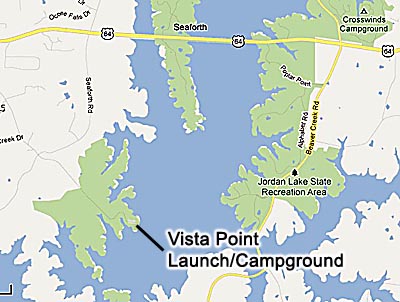
Vista Point State Park Launch Access/Campground: 35°42'13.48"N 79°
2'51.01"W
Kayak put-in location ("sailboat launch beach"):
35°42'15.91"N 79° 2'49.94"W
On Pea Ridge Road, 3.5 miles south of US 64. Just west of
the two Jordan Lake bridges on US 64 turn south onto Seaforth
Road (west of the Seaforth lauch area). Go south 1.9 miles
to the intersection with Pea Ridge Road. Turn left (east) onto
Pea Ridge Rd. Go .75 miles to the State Park gate and "pay
booth". Fee is $6.00 per car.
Download the .kmz file for this location report (for
Google Earth) - TheCasualKayaker_JordanLake_VistaPoint_north_4-14-12
Download the combined .kmz file
for all location reports -
TheCasualKayaker_Combined_LocationReports.kmz
If you don't have Google earth, you can still view
the track on Google earth in this
window.

B. Everett Jordan Lake is located in the northeastern
corner of Chatham County, North Carolina. Access to this
part of the expansive manmade lake is easy via highway US 64
west of Apex, NC. Other ways to reach it are on NC 751 from
I-40 south of Durham, NC, to US 64 and from Chapel Hill, NC
via Mount Carmel Church Road off US 501 at the intersection
of NC 54, NC 86 and US 501. Mt. Carmel Church Road turns into
Farrington Point Road which intersects US 64.
The weather was supposed to be just about perfect for paddling
this Saturday, and I wanted to try a different spot than those
of recent trips. I'd been concenrating lately on the marshy
areas of Jordan Lake, hoping to find good spots where birds
were handy for my photography. In fact, I'd gone paddling the
day before to the Panther Creek marsh area off NC 751 once again
for some photography. It was a nice paddle, but didn't provide
much in the way of birds within reach for useful photos.
Since the wife and one of my sons was going along, I figured
they wouldn't want to spend a lot of time hanging around while
I tried for photos. I decided to try out a new spot, at Vista
Point, where I thought we could just paddle and explore. In
fact, I only packed one camera body with a wide angle zoom for
general scenic shots, leaving behind all my telephotos for bird
photography - BIG MISTAKE.
The weather did turn out just about perfect (sunny and 70's)
but there was a pretty stiff breeze on and off. I was afraid
we wouldn't get to do much paddling. We arrived at Vista Point
Campground area around 10:30, paid the one-vehicle $6.00 fee
for day use and drove on in. There was only one vehicle in the
boat trailer parking lot. I had figured surely on a fine Saturday
morning at the end of Easter break week it would be much busier
than that. We unloaded our kayaks and gear at the "sailboat
launch" spot in a little sheltered cove where there was a sandy
beach well suited for kayaks.
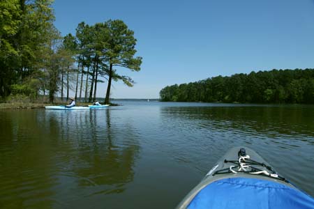
Once underway we headed south as per my plan after looking things
over on Google Earth the night before. Out of the shelter of
the little cove we immedately ran into a stiff wind out of the
south. The headwind and choppy water was not going to work for
us as I'd feared, so we turned north instead, hoping to find
more sheltered paddling. Thankfully we did, as the layout of
the lake worked to our advantage. We very quickly came upon
an Osprey nest directly at the shore's edge, with two Osprey
coming and going, and putting on a show for us. I wasn't sure
whether there were chicks already, as they both were flying
off the nest, but not for long.
Of course, I didn't have any long lenses with me. Since it was
very close to the launch point, I figured I could come back
later with my serious telephoto and tripod. I could then just
hike out along the shoreline to the location and maybe get some
photos that way. So on we went, very soon finding a lot of strange
splashing among the weedbeds all along the shore here. It soon
became apparent the fish must be spawning, as we could see them
writhing around in the weeds, tails and fins often out of the
water, and splashing about as if they were stranded in shallow
water. I'm not the fishing type, so I'd never seen this sort
of activity before, but it was cool to be able to paddle right
up next to this actitivy and witness it from arm's reach away.
The fish were no less than a foot in length and larger, shining
orange and golden in the light, but I have no idea what kind
they were.
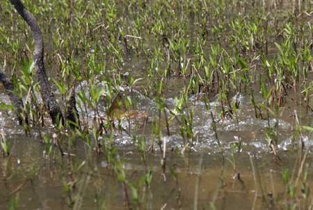
The golden back and dorsal fin of the fish
is plainly visible in this photo
of the splashing that was going on among the weeds.
We lingered all along the shoreline for some time, paddling
from spot to spot whenever more splashing would break out just
a little farther ahead. I tried getting some shots of the activity,
but didn't have any great luck with it. A couple of the shots
(like the one above) do give some idea of the scene though.
Eventually we tired of it and moved on farther north, following
close to the shoreline to minimize the affects of the breeze.
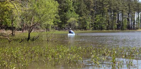
Checking out the weedbeds along the shore
where the fish were spawning.
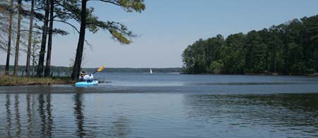
We spotted Cormorants and other Osprey as we paddled the wooded shoreline northward. There were several quiet coves along the way, and we took our time, just sightseeing with no actual destination in mind. There was very minimal boat traffic, and what there was stayed far out into the lake. We had little bother from boat wakes. I didn't even take many photos, as this had been planned as a "getaway" from my usual concentration on photography. I tried instead to just paddle and look, so I only have the couple of photos below of the view. Like the rest of Jordan Lake, the shoreline view is virtually devoid of buildings and distracting elements. You'll find only trees here.
After
a couple of hours paddling and a light lunch in a quiet cove,
we headed back. When we reached the cove where we'd seen all
the spawning activity, we kept near the weedbeds to see if there
was still any activity. At that point I spotted a young, mostly
brown, eagle flying by. It landed in a tree for a bit, then
moved on. I wondered if it had been eyeing the fish in the weedbeds,
as they seemed to me to be an easy target for an eagle's afternoon
snack. I turned my kayak around to scan over the weedbeds again
when I was quite surprised to spot an adult eagle sitting calmly
in a tree above the weedbeds very close to us. To my continued
astonishment, it seemed completely unpurturbed by our presence.
It quietly sat there the whole time while I mentally flogged
myself for not bringing any long lenses for such an occasion.
All I had was a wide angle zoom, which provided only an effective
2X magnification. It was barely enough for a decent shot of
a fish next to the kayak, and hardly suitable for bird photography.
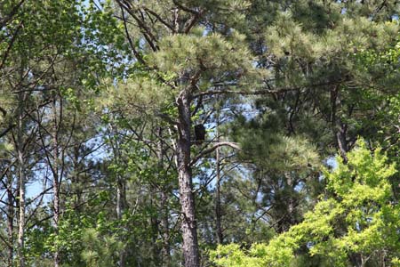
Above is the full frame of the photo I got with the wide lens.
You can probably tell there is an eagle in the pine tree in
the center of the photo. However, the good news is that the
camera I was using had super resolution. I cropped the photo
down to show the resulting image at actual size, which makes
it a much better photo, shown below.
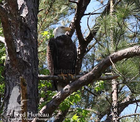
So, while this shot is not really good enough for my wildlife
photography work, it's not too shabby for my kayaking location
reports I suppose. But I learned a lesson - take the camera
gear, even when you THINK you won't need it. Murphy's Laws apply
to photography the same as everything else.
To close out this report I'll add that the Vista Point campground/launch
location has nice restroom facilities, paid for by your entrance
fee. We plan to return when there is less wind and explore southward
from the campground to see what we can find of interest there.
I hope to do this though before the busy season hits. I expect
it will soon be crowded with boats and the boat wakes will become
a problem and spoil an otherwise nice paddle location.
"If you're not paddling, you're not getting
anywhere."
|
|
|
|
| Article
Listing |
- Welcome
to "The Casual Kayaker"
- My
Rating System
- (B.
Everett) Jordan Lake - Farrington Point (northwest finger)
- June 18, 2011
- Paddling
in the Great Smoky Mountains, Jackson County, NC
- Bear
Creek Lake, Jackson County, NC, June 29, 2011
- Lake
Glenville, Jackson County, NC, June 30, 2011
- Wolf
Creek Lake, Jackson County,NC, July 1, 2011
- Kayaks,
Water, and DSLR Cameras - How I Manage Mine
- Our
first kayaks
- (B.
Everett) Jordan Lake, NC 751 area, July 16, 2011
- Hauling My Kayaks - A Little Do-It-Yourself
- Waiting
out the weather
- Short
Paddle on the Coast for Wild Horses
- (B.Everett)
Jordan Lake, return to NC 751 area, November 19, 2011
- (B.
Everett) Jordan Lake - Farrington Point to Morgan Creek
- April 1, 2012
- (B.Everett)
Jordan Lake, White Oak Creek marsh, April 7, 2012
- (B.Everett)
Jordan Lake, Vista Point - north, April 14, 2012
|
INTRODUCTION
When
I first began kayaking I found a most helpful blog
by Tom Haynie that aided me greatly in finding and
choosing new flatwater locations. His blog was infinitely more
detailed and useful than anything I found on kayaking forums.
I quickly resolved to share my own impressions of locations
I've visited, including details I believe to be important and
helpful, in hopes of providing practical information to others.
I sincerely hope you find something useful and helpful here.
(For more location reports visit Tom's blog at backshortly.wordpress.com)
|
Kayaking
Links
Paddling.net
- More Locations
Paddling.net
- Launch Sites Map
Download
Google Earth (free)
My Other Web Sites-
CarolinaWildPhoto.com
CarolinaOuterBanks.com
NCWildHorses.com
GossamerTrilogy.com
|
|