|
| (B.
Everett) Jordan Lake - Farrington Point to Morgan Creek - April
1, 2012 |
Jordan
Lake - Farrington Point to Morgan Creek 
April 1, 2012
Attribute Rating - (view
rating system scale) |
| Scenic
Quality |
3.5 |
| Wildlife |
3.5 |
| Water
Quality |
3.5 |
| Quietude |
4 |
| Boating
Traffic |
3.5 |
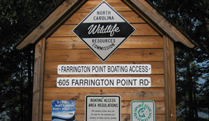
Boat ramp/ kayak put-in location: 35°48'10.34"N
79° 0'51.48"W
Wildlife Resources Comm. Farrington Point Boating Access, 605
Farrington Point Road (Google Earth missed this address by
a good 700 feet!, but my coordinates and marker are right on.)
Destination point: 35°50'32.29"N
79° 0'19.46"W - Morgan Creek marsh area
Download the .kmz file for this location report (for
Google Earth) - TheCasualKayaker_JordanLake_4-1-12.kmz
Download the combined .kmz file
for all location reports -
TheCasualKayaker_Combined_LocationReports.kmz


B. Everett Jordan Lake is located in the northeastern
corner of Chatham County, North Carolina. Access to this
expansive manmade lake is easy via NC 751 or Farrington Point
Road from highway US 64 west of Apex, NC. Other ways to reach
it are on NC 751 from I-40 south of Durham, NC, and from Chapel
Hill, NC via Mount Carmel Church Road off US 501 at the intersection
of NC 54, NC 86 and US 501. Mt. Carmel Church Road turns into
Farrington Point Road which intersects US 64. ( Note that there
is a village close-by spelled "Fearrington" Village, but the
road and boating access is spelled "Farrington". Don't let that
cause confusion when mapping or planning. )
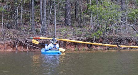
This was not your usual "kayaking" trip, as I didn't take my
kayak, though the wife did take hers. I opted for my camouflaged
duck boat for this trip - not because of the camouflage, but
because of the trolling motor on it. This was a solid 8-mile
trip, and I knew neither of us could manage that distance in
an afternoon of paddling. I wanted to check out the Morgan Creek
marsh area while the spring lake level was high enough. Last
summer the lake was so low I would've had to hike a third of
this trip! The plan was to try towing the wife in her kayak
as far as possible, hoping the battery and motor would handle
it. Lucky for us it worked just fine. It sure made the trip
easier and faster, and she enjoyed the free ride.
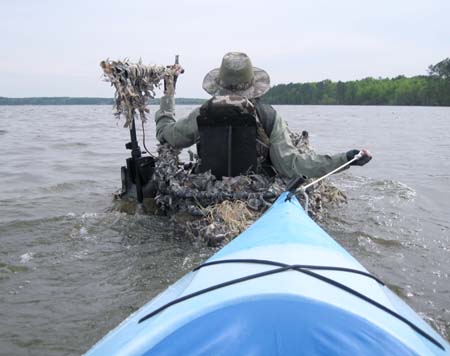
Towing the wife in her kayak
with my duck boat and trolling motor worked out even better
than I had expected.
I have to admit that for me it wasn't as much "fun" as paddling,
but then I knew this particular trip was not going to be much
fun. It was simply too far in too short of a time allotment.
It was a "get there and get back" sort of thing. There would
not be much time for exploring as we went. In fact, there wasn't
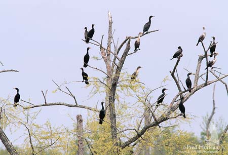
that much to see, other than an unusually busy day for the birds
for some reason. Someone at the launch ramp mentioned to us
while we were loading up just how many birds there were out
that day, and it turned out to be true. We saw quite a few Osprey,
cormorants and gulls as we headed out.
The birds thinned out a bit the farther north we went toward
Morgan Creek, so we chugged along while the trolling motor churned
away for all it was worth. We followed along the western shoreline
for what seemed an eternity, finally reaching the shallows by
the marsh. Waiting for us was a greeting committee of cormorants,
at least 60-70 of them, in and under some trees along the edge
of the marsh.
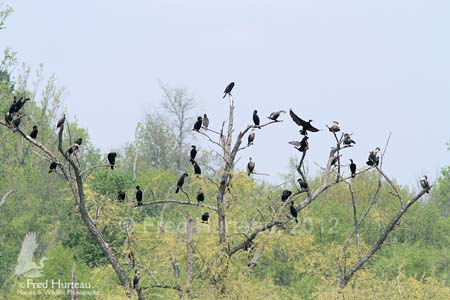
The welcoming committee.
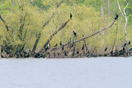
We slipped closer for some photos but the cormorants did not
hang around for long, choosing to let us have the place to ourselves.
We didn't try going back up into the marsh at all, as there
was not much time for exploring to begin with, and the trolling
motor requires a bit more depth than the kayaks. The lake level
was at 217.2 on this day, and I could tell trying to do much
here with the trolling motor wasn't going to be fruitful. I
was already hitting bottom with the prop while skirting along
the outer edge of the marsh, so going any farther in would be
a hassle at best. The lake had been 3 feet higher just 5 days
earlier, and now that I'd had a chance to check the place out
it was obvious that I could have gone a good distance up into
the marsh with that kind of depth.
In the meantime the wife paddled off on her own now that we'd
reached our destination point, and I clunked around in the duck
boat. It's nowhere near as nimble as the kayaks, and tracks
only slightly better than a tire tube. It's great for what I
got it for, but it's really not well suited for open water.
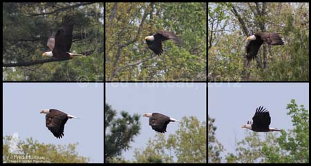
We soon headed for the eastern shoreline and immediately spotted
an eagle sitting in the top of a dead tree. I pulled out my
long lens (well, the longest one I had with me) and managed
to get a few distant shots before it dove from the tree and
flew north.
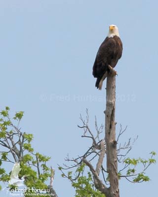
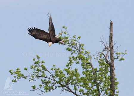
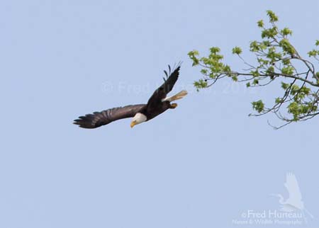
I followed it, snapping off shots as it flew, and ended up with
several shots. They're too far off to be very useful, but I
put them together into a collage to post below.
With the eagle gone, we took a few minutes to explore a little,
working back into the northeastern corner as shown by the GPS
track in the .kmz file associated with this report. We spotted
little further bird activity here, so we soon headed back. I
had learned what I came to find out, and we had a long ride
back before the day ran out on us.
We had spotted some sort of yellow pipe up in the trees way
off on the eastern shore on our way in, so we decided to check
that out on our way back. Soon we reached the curiosity, and
realized it must be some sort of floating boom. I've since learned
there is usually a yellow boom stretched across the lake in
the spring to keep boats out of this area. This didn't appear
to be long enough to reach across the lake however, and we could
not figure out how it had gotten up so high into the tree limbs.
Not even a lake level of 220 could have put it that high.
The curious yellow "pipe" we
found had to be a floating boom.

We could not figure out how it
got so high up into the tree limbs.
Still scratching our heads over the tree-climbing boom, we went
back into the "towing mode" and headed out for the long ride
back to Farrington Point. There was little to see of particular
interest on the way back, except for several large "V" formations
of cormorants flying west to east. There must have been upwards
of 200 of them altogether. I've only seen large numbers of them
like that at the coast. The four miles back to Farrington Point
seemed endless, but we finally arrived, hauled everything out,
loaded up and headed home.
It's quite a long way to reach Morgan Creek. I don't plan to
try returning unless the lake level is really high so the marsh
area will be extensive enough to make the trip worthwhile.
"If you're not paddling, you're not getting
anywhere."
|
|
|
|
| Article
Listing |
- Welcome
to "The Casual Kayaker"
- My
Rating System
- (B.
Everett) Jordan Lake - Farrington Point (northwest finger)
- June 18, 2011
- Paddling
in the Great Smoky Mountains, Jackson County, NC
- Bear
Creek Lake, Jackson County, NC, June 29, 2011
- Lake
Glenville, Jackson County, NC, June 30, 2011
- Wolf
Creek Lake, Jackson County,NC, July 1, 2011
- Kayaks,
Water, and DSLR Cameras - How I Manage Mine
- Our
first kayaks
- (B.
Everett) Jordan Lake, NC 751 area, July 16, 2011
- Hauling
My Kayaks - A Little Do-It-Yourself
- Waiting
out the weather
- Short
Paddle on the Coast for Wild Horses
- (B.Everett)
Jordan Lake, return to NC 751 area, November 19, 2011
- (B.
Everett) Jordan Lake - Farrington Point to Morgan Creek
- April 1, 2012
- (B.Everett)
Jordan Lake, White Oak Creek marsh, April 7, 2012
- (B.Everett)
Jordan Lake, Vista Point - north, April 14, 2012
|
INTRODUCTION
When
I first began kayaking I found a most helpful blog
by Tom Haynie that aided me greatly in finding and
choosing new flatwater locations. His blog was infinitely more
detailed and useful than anything I found on kayaking forums.
I quickly resolved to share my own impressions of locations
I've visited, including details I believe to be important and
helpful, in hopes of providing practical information to others.
I sincerely hope you find something useful and helpful here.
(For more location reports visit Tom's blog at backshortly.wordpress.com)
|
Kayaking
Links
Paddling.net
- More Locations
Paddling.net
- Launch Sites Map
Download
Google Earth (free)
My Other Web Sites-
CarolinaWildPhoto.com
CarolinaOuterBanks.com
NCWildHorses.com
GossamerTrilogy.com
|
|